
Spatial integration in European border regions is a dynamic geographical phenomenon. It shows different patterns along European inner borders and it can change over time. The case of the Bavarian-Czech border region is a very inspiring case in this regard as the spatial separation was very strict for decades (‚iron curtain‘) and as political ambitions for further integration are currently strong.
On Friday, 30th June, a group of Czech and Bavarian researchers met for a workshop in Erlangen to discuss theses patterns in the framework of the INTEGRA project funded by the Bavarian-Czech Academic Agency (BTHA). The objective of the short term project is to conduct an exploratory study linking the academic paradigms of research on spatial integration with small scale spatial data.
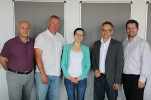
Foto of the workshop participants (from left to right): doc. PaedDr. Jaroslav DOKOUPIL Ph. D. (Pilsen), RNDr. Tomáš HAVLÍČEK, Ph.D (Prague), Anna HEUGEL M.A. und Prof. Tobias CHILLA (Erlangen), Ing. Jan TLUČHOŘ, Ph.D. (Pilsen, Cheb). Not on the foto: Mgr. Ing. Luděk FRÁNӖ (Prague, Budweis).